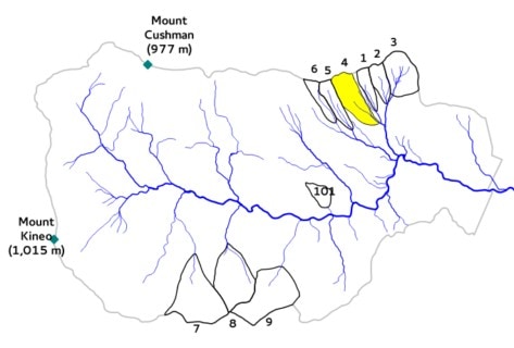
Watershed 4
Area: 36.1 ha
Slope: 15.6°
Aspect: S 40° E
Elevation: 442-747 m
Gage type: V-notch weir
Initial year: 1960

Description: A progressive strip cut was applied to W4 to determine the effect of this more moderate cutting technique on forest regeneration, stream water yield, and nutrient export. In a progressive strip cut, all trees are removed by periodic cutting of adjoining strips over several years. Strip cutting is a less intensive method of harvesting compared to clearcutting, because the trees are removed over multiple years, thereby minimizing effects on stream water chemistry and flow. Prior to the cut, W4 was surveyed and divided into 49, 25-m wide strips that were roughly parallel to topographic contours. Every third strip was cut at two year intervals and all merchantable materials were removed by the contractor using rubber-tired cable skidders. The first series of strips was cut in October 1970 (see Figure 1) and the second series of strips, immediately downhill from the first series, was cut in fall 1972. After the third and final set of strips was cut in 1974, the entire watershed had been harvested except for an uncut buffer zone that was left along the stream channel.
Objective: To determine how progressive strip cutting affects nutrient and hydrological cycling and stand regeneration relative to clearcutting.
Treatment: Progressive strip cut, 1970-1974
Strip cut in three phases during the autumns of 1970, 1972 and 1974.
Strips were roughly parallel to watershed contours and were progressive 25 meter wide swaths.
All merchantable materials were removed.
Resulting Observations:
Streamwater nutrient concentrations and water yield increased during and immediately after strip cutting, but not as much as following clearcutting of Watersheds 2 and 5.
At year 10, the strip cut had a more desirable mix of commercial species than the block cut on Watershed 101, with higher densities of yellow birch and sugar maple and lower densities of pin cherry.
In 1992, the vegetation on all strips was inventoried resulting in average biomass of 88 t/ha.
Continued research/treatment: Monitor changes in water yield, stream chemistry and vegetation.
Datasets:
Daily streamflow
Streamwater chemistry
Nutrient Flux (Streamwater)
Nutrient Flux (Precipitation)
Sediment yield in weir basin
Phenology measurements
